

World War II from Above: A History in Maps and Satellite Photographs
£16.50£19.00 (-13%)
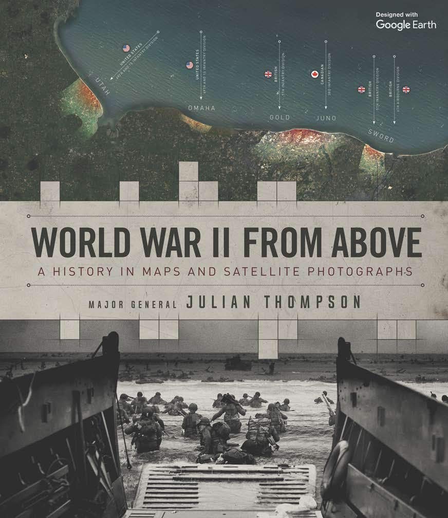
World War II from Above offers a never-before-seen combination of annotated satellite images and expertly drawn battle maps. It aims to satisfy both the military history buff and those seeking a visually stunning history gift book, bringing the war vividly and dramatically to life by showing the actual landscapes where battles took place along with specially commissioned annotations depicting remarkable events, troop movements, heroic last stands, or even where individual soldiers stood or fell.
Each of the 25 chapters features an enhanced Google Earth image, along with specially commissioned battle maps showing every facet of the conflict in exceptional detail.
Here you will find all the key milestones of World War II: the invasion of France, Germany’s first blitzkrieg offensives, the Battle of Alamein, Monte Cassino, Arnhem, the invasion of Sicily, the Battle of the Bulge, Iwo Jima, D-Day and the final push to Berlin, along with a host of other strategic and battle maps from every geographical location.
Written by a highly decorated soldier and leading military history expert, this is an innovative, richly detailed and visually stunning overview of history’s most destructive conflict.
Read more
Additional information
| Publisher | Welbeck Publishing (9 July 2020) |
|---|---|
| Language | English |
| Hardcover | 160 pages |
| ISBN-10 | 0233006125 |
| ISBN-13 | 978-0233006123 |
| Dimensions | 25.7 x 2.1 x 22.4 cm |


by Robin Hamman
I love the conceptual idea of this book and, overall, it is worth spending a long evening flicking through.
However, I’ve spotted a lot – every 10 pages or so – mistakes that any decent editor should have picked up. That’s annoying.
Worse are the factual errors. Here are two examples of the five or six such errors I, a non-historian, spotted:
The date of a SS General’s “mysterious” death in France is listed as 1971 when it was actually years later. Local police also found strong evidence (4 molotov cocktails, cut perimeter wires, many discharged rounds, wounded dogs…) it was an arson attack, rather than some “mysterious occurance”. Later, in the pages on the fall of Berlin, the Russians had both 41,600 and 9,303 artillery pieces. Which was it?
Such errors undermine my confidence, not only in those particular “facts”, but in every other detail presented as “fact” in the book.
I suspect that the editor, rather than the author, is to blame for these issues, but with my confidence in this title’s correctness now undermined, I couldn’t possibly recommend it to others.
by Robin Hamman
Bought as a Christmas gift. Recipient very happy. Good purchase and arrived promptly.
by Patrick Stephens
Too little on each battle. Thought was going to be in more depth and provide many more maps and aerials. No aerials from the 40s
by Robert Askey
Frankly a bit dull.
by Lynda green
An easy read enjoyed the pictures and comments.
by Jon
Great book & photos, interesting perspective. Something different to read.
by JD
Gift for WWII history enthusiast to add to collection, loved satellite photos.