Geography
-
Atlas of the Invisible: Maps & Graphics That Will Change How You See the World
Winner of the British Cartographic Society Award 2021
Winner of the John C Bartholomew Award for Thematic Mapping 2021
Winner of the Stanfords Award for Printed Mapping 2021Discover the hidden patterns in human society as you have never seen them before – through the world of data
In Atlas of the Invisible, award-winning geographer-designer team James Cheshire and Oliver Uberti redefine what an atlas can be. Transforming enormous data sets into rich maps and cutting-edge vizualisations, they uncover truths about our past, reflect who we are today, and highlight what we face in the years ahead. With their joyfully inquisitive approach, Cheshire and Uberti explore happiness and anxiety levels around the globe; they trace the undersea cables and cell towers that connect us; they examine hidden scars of geopolitics; and illustrate how a warming planet affects everything from hurricanes to the hajj.
Years in the making, Atlas of the Invisible invites readers to marvel at the promise and peril of data, and to revel in the secrets and contours of a newly visible world.
Read more
£19.00£23.80 -
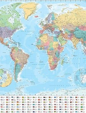
Collins World Wall Laminated Map
Explore the world with a Collins wall map
Fully updated world map to include the latest political changes. Contains politically coloured mapping showing each country and their capital city, major roads, railways and cities and towns clearly. Also included are national flags, key statistics for every country and inset maps of the polar regions.
This laminated (on front side only) map is printed on high quality paper and comes rolled in a plastic tube – ideal as a poster for any classroom, bedroom or office wall.
Area of coverage:
All of the world, centred on the Greenwich Meridian, and including maps of the North and South Pole regions.Scale:
1:22 000 000; 1 cm to 220 km; 1 inch to 347 milesSize:
1015 x 1380 mm (40 x 54 inches)Other versions available:
Paper flat map in tube (ISBN 978000821158-5).Read more
£11.40£12.30Collins World Wall Laminated Map
£11.40£12.30 -
Everything: World War II: Facts and photos from the front line to the home front! (National Geographic Kids)
Fact-packed topic books for primary school children
Brave soldiers, important battles, life on the Home Front! It’s time to learn everything about the Second World War.
Packed with facts, pictures and maps it’s ideal for homework, topic work, KS2 school projects and anyone who is simply curious about history.
· colourful photography and illustration
· hundreds of interesting facts
· maps, diagrams, interactive glossary, and more!Read more
£7.00£7.60 -
France 2024 – Tourist & Motoring Atlas A4 Laminated Spiral
Michelin’s France 100% laminated A4 atlas offers, in addition of Michelin’s clear and accurate mapping, an enhanced view of your journey thanks to its scale 1/250,000. Convenient and easy to use thanks to its spiral bound cover, this atlas comes with extra-resistant laminated pages on which you can trace and erase your journey. The route planner as well as the time distance charts will help you plan and optimise journey. Michelin’s new safety alerts warn you about dangerous driving areas and zones subjet to tighter speed checks. Michelin’s laminated France atlas also includes information on tourist sights, leisure facilities and scenic routes, as well as service areas to add pleasure and comfort to your journey. Michelin’s France laminated tourist and motorist atlas features: * Scale 1/250,000: for an enhanced view of your journey * Extra resistant pages: to draw/erase your journey as you go along * Key to map pages: to quickly access the region of your interest * A complete town index: To easily indentify to destination of your choice * Distance and time chart: to help you plan your trip * 6 major town plans: Paris, Bordeaux, Lille, Lyon, Marseille & Nantes * Michelin’s danger alers: to help you identify zones at risks for drivers and controlled speed areas * In English language: Keys, indexes and informationRead more
£19.99 -
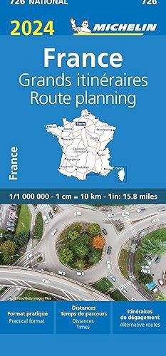
France Route Planning 2024 – Michelin National Map 726: Map
Updated annually, MICHELIN National Map France Route Planning (map 726) will give you an overall picture of your journey thanks to its clear and accurate mapping scale 1/1 000 000 Our National Map Series will help you easily plan your safe and enjoyable journey thanks to a comprehensive key, a complete name index as well a clever time & distance chart. Michelin’s driving information will help you navigate safely in all circumstances. In addition, some MICHELIN National Maps are cross-referenced with the MICHELIN Green Guide highlighting destinations worth stopping for! With MICHELIN National Maps, find more than just your way! MICHELIN NATIONAL MAPS feature: * Up-to-date mapping * A scale adapted to the size of the country * A clear and comprehensive key * Distance and time chart * Place name index * Driving and road safety information * Tourist sights information Our maps are regularly updated even if the ISBN does not change.Read more
£6.60 -
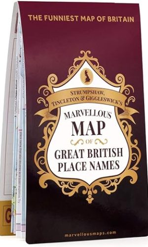
Great British Place Names Map | Funny Map & Guide | Marvellous Maps | Humour | British Gift | British Geography
Discover Great Britain’s funniest, strangest and rudest place names from Fulking Hill to Wigtwizzle. Plan your own ‘Rude Trip’ to explore the glorious eccentricity of British place names.
- Features over 2,000 genuine homegrown funny, rude and quirky British place names
- Laugh and learn with the top 50 British place names chosen by ST&G cartographers
- Take a road trip connecting the best British place names or plan your own
Features of the Great British Place Names Map:
- Fold-out map and reference guide showing all of Britain’s best and weirdest place names on a single sheet
- Printed full-colour and two-sided on Progeo professional mapping paper
- Reverse features space to plan, add lists and notes or even rest your mug
- Dreamed up, designed and made in Britain
- Other Great British maps include the Great British Adventure Map and the Great British Film & TV Map
Read more
£9.70£14.20 -
Most Popular
After travelling the whole world, can exploring a single map ever be enough?
Adventurer Alastair Humphreys spends a year investigating the small map around his own home.
Can this unassuming landscape, marked by the glow of city lights and the hum of busy roads, satisfy his wanderlust? Could a single map provide a lifetime of exploration?
Humphreys discovers more about the natural world than in all his years in remote environments. And he wakes up to the terrible state of British nature, land use, and freedom to roam the countryside. This is an ode to slowing down and the meaningful experience of truly getting to know your neighborhood.
Local is a celebration of curiosity, time spent outdoors, and a rallying cry to protect the wild places on our doorstep. It is a reminder for all of us that nature and wildness are closer than we think.
Narrated by the author.
Read more
-
Ode to the Sea: Poems to celebrate Britain’s maritime heritage
Anthology of poetry celebrating Britain’s maritime history.
A wonderful anthology of poetry celebrating the British coastline and life above and below the deep blue sea. Verses from our best-loved authors – such as WB Yeats, RL Stevenson and Rudyard Kipling – are accompanied by beautiful illustrations of idyllic days at sea, haunted shipwrecks and tempestuous storms. Sea shanties and siren’s songs sit alongside the classic song from The Tempest and Coleridge’s ‘The Rime of the Ancient Mariner’ in this beautiful anthology of the mystical world beaneth the waves.
Read more
£11.40£12.30 -
Rewilding the Sea: How to Save our Oceans
**LONGLISTED FOR THE 2023 WAINWRIGHT PRIZE**
‘Desperately needed’ – Isabella Tree
‘I doubt any more important book will published this year’ – Stephen Fry
In this indispensable follow up to his acclaimed The End of the Line: How Overfishing is Changing the World, Charles Clover chronicles how determined individuals are proving that the crisis in our oceans can be reversed, with benefits for both local communities and entire ecosystems. Rewilding the Sea celebrates what happens when we step aside and let nature repair the damage: whether it is the overfishing of bluefin tuna across the Atlantic, the destruction of coral gardens by dredgers in Lyme Bay or the restoration of oysters on the East Coast of America.
The latest scientific research shows that trawling and dredging create more CO2 than the aviation industry and damage vast areas of our continental shelves, stopping them soaking up carbon. We need to fish in different ways, where we fish at all. We can store carbon and have more fish by stepping aside more often and trusting nature.
Essential and revelatory, Rewilding the Sea propels us to rethink our relationship with nature and reveals that saving our oceans is easier than we think.
Read more
£11.40£12.30Rewilding the Sea: How to Save our Oceans
£11.40£12.30 -
Technical Due Diligence and Building Surveying for Commercial Property
Technical Due Diligence and Building Surveying for Commercial Property is the first book to introduce the process of technical due diligence (TDD) and examine the role of the building surveyor within the commercial property sector. The book outlines the processes that the surveyor must go through when performing a TDD inspection and report and, most importantly, covers in detail the typical pathology and defects encountered during TDD.
Performing a TDD survey involves collecting, analysing and reporting on a huge amount of information, often under specific contractual conditions. The book covers everything the surveyor needs to know in order to do a proper job and includes analysis of materials, life cycles and potential defects on an elemental basis, with detail on individual components where necessary.
Coverage includes:
• an introduction to the TDD process and types of commercial buildings encountered
• chapters outlining the life cycle and defects of: structures, roofs, facades, finishes and services
• hundreds of illustrations and photographs of defects, real-world case studies and suggestions for further reading
• a final chapter covering legal issues and technical details.
This book fills a clear gap in the literature and is the first fully illustrated book on TDD dedicated to commercial building stock. It will help students and professionals to understand the process, the science involved and the reasons why defects occur, as well as their evolution and long-term impact.
Read more
£45.10 -
The Encyclopedia of Wonders: 1001+ Interesting Facts for Curious Minds Book for Kids │Super Fun Facts Books for Smart Kids│Big Ideas for Curious Mind
Embark on a Learning Adventure with “The Encyclopedia of Wonders”
Discover the magic of learning with “The Encyclopedia of Wonders,” a captivating and comprehensive collection of over 1000 extraordinary facts. This richly illustrated book is not just a treasure trove of knowledge; it’s a bridge to new worlds of understanding and creativity for children and young adults.
What Makes This Book Special?
- Educational Value: Each of the ten chapters is meticulously crafted to educate and inspire, covering a range of topics from the natural world to the mysteries of the cosmos.
- Develops Critical Thinking: Encourages young minds to ask questions, seek answers, and develop a love for science and exploration.
- Enhances Reading Skills: An excellent resource for improving reading comprehension and vocabulary in a fun and engaging way.
- Interactive Learning: With pages that children can color, this book not only teaches but also helps develop fine motor skills and artistic expression.
- Family Bonding: A perfect opportunity for parents and children to explore and learn together, fostering stronger family connections through shared discovery.
Dive Into the Chapters:
- Amazing Nature
- Wild Animals
- Plants and Trees
- Ecosystems
- Weather and Natural Phenomena
- Space and Astronomy
- Stars and Galaxies
- History of Space Conquest
- Exact Sciences
- Mathematical Curiosities
Why Choose “The Encyclopedia of Wonders”?
- Inspires Curiosity: Sparks a sense of wonder and curiosity about the world, encouraging lifelong learning.
- Broadens Horizons: Exposes readers to a diverse range of subjects, broadening their understanding and appreciation of the world around them.
- Quality Time: Offers an ideal way for families to spend quality time together, learning and growing.
- Gift of Knowledge: The perfect gift for any child or young adult, providing endless hours of educational entertainment.
Begin Your Journey Today!
“The Encyclopedia of Wonders” is more than a book—it’s an invitation to embark on an unforgettable journey of learning and wonder. Add it to your cart now and unlock a world of knowledge and inspiration for your child!
100% Satisfaction Guarantee: We are confident in the value and quality of “The Encyclopedia of Wonders.” If you or your child are not completely satisfied, you can return the book for a full refund, no questions asked.
Read more
£3.80 -
Yorkshire Dales National Park Pocket Map: The perfect guide to explore this area of outstanding natural beauty
Handy little full-colour map and guide of Yorkshire Dales National Park.
Detailed mapping and visitor information to the National Park along with a selection of photographs. Map at a scale of 1:140 000 (1cm to 1.40km, 2.2 miles to 1 inch).
This small map with additional text and photographs gives a great overview of the Yorkshire Dales National Park, and is the perfect companion for exploring this beautiful area of Northern England.
- Clear, detailed mapping
- Key park, tourist and travel information
- Ideal for planning visits to the National Park
- Index to help locate and plan your trip
This and the Yorkshire Dales Park Rangers Favourite Walks (ISBN: 9780008462659) are the perfect companions for exploring this superb walking area of England.
Read more
£1.90£3.80


