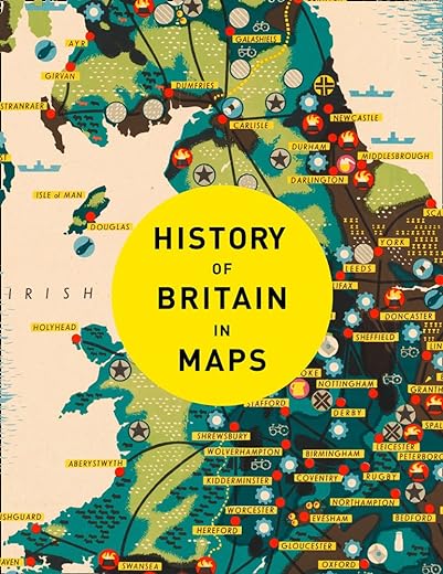


History of Britain in Maps: Over 90 Maps of our nation through time
£11.40£23.80 (-52%)
Discover the history of the United Kingdom through maps
From Mappa Mundi to modern election maps, the United Kingdom has evolved rapidly, along with the ways in which it has been mapped. In this time, cartography has not only kept pace with these changes, but has often driven them. In this beautiful book, more than 90 maps give a visual representation of the history of Britain.
Every map tells a story and this book tells the incredible history of Britain through maps, and includes many famous examples of cartography, along with some that deserve to be better known. See the establishment of Great Britain, the British Empire expand, the impact of World Wars and the latest statistical mapping.
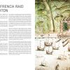
Maps include
• Rudge Cup (schematic map of western forts on Hadrian’s Wall), 2nd century AD
• Matthew Paris map of the Anglian Heptarchy (Anglo-Saxon Kingdoms), c. 1250
• Gough map of Britain, 1360
• Cambriae Typus, first published map of Wales, 1573
• Raven maps of the Ulster Plantations, 1622
• Enclosure map (eg of Norfolk, c. 1800)
• Booth Poverty Map of London, 1886
• Map of Beeching cuts to Britain’s railways, 1963
• Map of EU Referendum voting patterns, 2016
Read more
Additional information
| Publisher | Collins (2 Nov. 2017) |
|---|---|
| Language | English |
| Hardcover | 256 pages |
| ISBN-10 | 0008258341 |
| ISBN-13 | 978-0008258344 |
| Dimensions | 21.59 x 2.54 x 27.31 cm |


by Hannah
Very good read (even better if one can read old English from the earlier maps). The old saying about a picture is worth a thousand words is sort of reversed here: the text is worth a thousand words.
by Hannah
Exactly what I wanted, but it is a gift and I was disappointed that the back was scuffed and there are marks on it.
by Amazon Customer
Bought as a present for a man!
by lisaandmaggie
A superb book which will appeal to historians, cartographers, and to the general reader alike. It covers maps from the 11th century to 21st century, ranging from the conjectural world map (showing Britain) to the small locational map e.g. H.M. the Queen’s coronation route in London. All the maps are full page (except where they are given a two page spread), and no map has more than one page of accompanying text.
by Mr. R. E. J. Hyson
Recipent was happy with what was in the book.
by Nicky Chesworth
This was a present for my dad for Christmas and he seems to really enjoy flicking through. There is a good variety of maps and the information accompanying them is detailed and easy to read. Overall it was a big hit!
by Harriet
Interesting to see how the outline of the british isles developed. But disappointing to find the later maps had no keys to describe the different colours and symbols.
by Carol Potter
A good book with detailed images